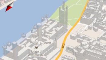
The Google Maps application for Android has been updated to add 3D images of buildings in major cities including London, Paris and Barcelona. The desktop version of Google Maps now also includes 3D buildings powered by vector graphics.
Google rolled out Maps 5.0 for Android in December 2010, but at the time the 3D images feature was limited to a handful of locations, such as New York City, Zurich and Milan. However, Google has since been adding more cities, and 3D buildings are now available in London, Paris, Barcelona, Stockholm, Singapore, Lisbon, Boulder, and 11 major cities in South Africa.
“Whether you’re on the go or playing with a new phone, seeing a 3D skyline is a helpful, fun, and unique experience,” said Google software engineer Brian Brewington in a 19 July blog post.
Vector graphics
Google’s 3D maps use vector graphics to “dynamically” draw the map on an Android device, allowing the user to tilt, rotate and zoom in on the images. Buildings appear as ghostly outlines between the streets, allowing users to pick out landmarks for navigation.

Dragging down with two fingers tilts the map, twisting with two fingers rotates the map, and sliding two fingers together or apart zooms the map in and out. Users can also tap the compass button in the top right corner to flip into 3D mode and start rotating to match their perspective.
Google previously downloaded the maps as sets of individual 256×256 pixel “image tiles,” each with their own section of map imagery, roads, labels and other features baked in. However, the new application uses vector tiles, giving Maps the flexibility to re-draw the same map from different perspectives using the same set of data.
“If you magnify an map image tile by 2x, lines such as roads and text would get twice as wide and appear blurry. As a result, we had to constrain Maps to 20 fixed “zoom levels,” each one twice as close as the last,” explained Google Maps software engineer Andrew Miller back in December. “Every time you zoomed in further, you’d need to download a completely new set of image tiles.
“With vector graphics, you no longer need to ’round’ to the nearest zoom level and then download all the tiles for that level. One vector tile has the underlying vector data (or blueprints) to draw the map at many different levels of scale.”
Miller explained that the 3D map interactions work the same way as zoom, using the same vector data to draw the map from any angle or direction as you tilt or rotate.
No update required
No official announcement has been made about 3D buildings on the desktop version of Google Maps, but a quick search of London landmarks reveals that many parts of the city have already been mapped in 3D – including the Houses of Parliament, Westminster Abbey and Shard London Bridge.
The Shard will be the tallest building in the European Union, but is still being built. It looks as if the 3D version in Google Maps is based on Google Maps’ satellite image from an early stage of construction, and has converted some of the building site’s cranes into vertical slabs.
Battersea power station and St Paul’s Cathedral are yet to emerge, but Westminster Abbey has a fine array of flying buttresses.
Android users wanting to check out the new buildings do not need to update the application, but will need a phone running Android 2.0 or newer, which supports 3D buildings.
True 3D views, of course are provided in Google Street View, which the search giant expanded last year to cover “almost all” of the roads in the UK. This lets British users of the virtual mapping service view 360 degree images of 238,000 miles of public road and thoroughfares, from Cornwall to the Shetlands.


